Today Niagara Region serves as a carbon sink thanks to its extensive wetlands south of the Niagara Escarpment. While over 90% of Southern Ontario’s wetlands have been drained, the degradation has not hit southern Niagara, where only 10% have been lost. These wetlands, mostly forested except the 1,500 hectare Wainfleet Bog, contribute to the cooling of our traumatically overheating earth.
Climate change will inevitably place greater strain on Niagara’s wetlands and these pressures will continue for over a decade, even if immediate positive policies are enacted throughout the world. It’s common knowledge – even when the stove is turned off hot water continues to boil for some time.
There is a danger that the lower summer precipitation that has impacted Niagara’s wetlands will turn them from carbon sinks to carbon emitters. Bog fires as witnessed in the Fort McMurray catastrophe can be quite horrific. Peat fires can emit great clouds of toxic smoke. Three thousand deaths are attributed to the Moscow peat fires of 2015.
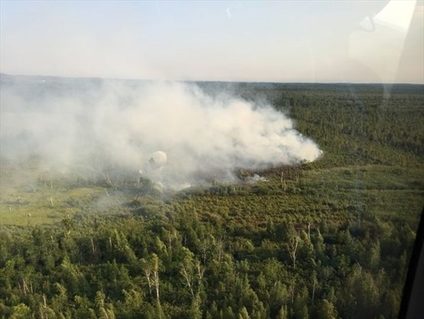
The most vulnerable area in Niagara is the Wainfleet Bog. Agricultural drainage and past peat mining continue to impact. The last fire in 2016 was a 6.4-hectare forested area damaged by mining and drainage. Tankers had to bring in 48,000 gallons of water to put the blaze out.
Peat mining for fertilizer removed the sphagnum moss layer from much of the former Open Heath Bog. This damaged habitat for the endangered massasauga rattlesnake which uses the sheltered moss as a winter hibernaculum. It also jeopardized the threatened Blanding’s and spotted turtles. While peat mining has stopped agricultural drainage continues to impact. The Bog is also negatively impacted by Wilson Road, the last major highway built through an extensive natural area in Niagara.
When human-induced climate change was less a problem in 1971, a bog fire in the Wainfleet Bog killed off its tamarack and black spruce trees. Climate change, fostering drier and hotter summers, has caused this problem to persist with fires erupting in 2012 and 2016.
Sphagnum moss still dominates the healthiest, coolest, open, most fire-resistant parts of the Wainfleet Bog. Its area expanded when most of the bog became owned by conservation agencies in 1996. The CA's rehydrated the bog by closing agricultural drains, facilitating the survival of heath vegetation such as the dominant sphagnum moss, leatherleaf, Labrador tea, sundew, cranberry, high bush blueberry, and cotton-grass.
The unusual wetlands of southern Niagara are all created by the former Lake Tonawanda which vanished as Lake Erie shrank around 4,000 years ago. It occupied the area in-between the Niagara and Onondaga escarpments. Both the Welland River and the Tonawanda Creek are at the lowest part of this vanished post-glacial lake.
The northern part of the Lake Tonawanda wetlands are swamp forests where drainage is reduced by heavy clay soils. These wetlands are characterized by an abundance of vernal (temporary) pools (also termed sloughs). In the spring these become breeding areas for such vernal pool-obligate species as anurans (frogs and toads), salamanders (blue spotted), and the eastern newt. Human-induced drainage has damaged with many forests now lacking slough characteristics.
While the northern part of former Welland County is characterized by heavy clay, south edges are deep muck formed during the time when Lake Tonawanda’s shallow waters were locked away from Lake Erie by the Onondaga Escarpment. While Wainfleet Bog is naturally largely an open Heath, the misnamed Humberstone Marsh is actually a treed peat bog. Much like the urban development threatened Thundering Waters swamp it is dominated by towering pin oaks and shagbark hickories. After the 1971 Wainfleet Bog fires, it became the last area in Niagara for blue spruce and white spruce.
While peat bog fires have not yet taken place in Humberstone Marsh it remains vulnerable to hotter, drier summers coming from climate change. The protected conservation area in the treed peat bog accounts for only 82 of its 381 hectares. Even this protected area is negatively dried by a poorly-conceived municipal drain serving farming lands owned by the Niagara Peninsula Conservation Authority (NPCA).
Priority in planning for both climate change prevention and adaptation should be given to protecting and expanding the remarkable wetlands of vanished Lake Tonawanda. The steps involved are numerous. Start with closing lightly traveled roads such as Wilson Road. Agricultural drains need to be closed, re-routed and modified. Zoning and land-use planning need to be rigorously applied to protect wetlands-adjacent and connecting lands. The vision for Lake Tonawanda should be as a great wildlife refuge, instead of golf courses or crackpot schemes such as the Canadian Motor Speedway.