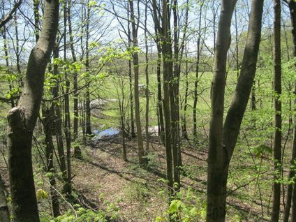
There is a narrow green wedge of 1.5 kilometers south of the Niagara Escarpment in the City of Niagara Falls. It is a thin refuge for wildlife between a concrete maze of an expressway, quarries, the Welland Canal and a rock dump. It is now under attack.
North of the green wedge is the Greenbelt, which stretches from Lake Ontario to the Niagara Escarpment. South is the most intact area of Carolinian Canada outside of designated Indian Reservations stretching to Lake Erie. It is dominated by the wetland forests created by the heavy clays of the vanished Lake Tonawanda.
The Carolinian Canada Big Picture Project has undertaken mapping which highlights the significance of the Green Wedge between two blocks of waste rock and cement. It is termed variously as an “Island Core” and as a “Meta Core”.
The core reality was shown by Dr. Michael Dickman, a long-time member of the Sierra Club, when he did surveys for frog calls in preparation for an Ontario Municipal Board (OMB) hearing. Dickman found that the only place south of the Escarpment between the Welland Canal and the built-up area of Niagara Falls was in the green refuge.
During the OMB hearing, Dickman took part in a walk on the disputed lands by experts of all parties. The all-party visits of experts identified a vernal pool in which breeding takes place for the Chorus Frog, Spring Peeper, and Wood Frog. It had been proposed, contrary to guidelines for storm water management, to be a storm water treatment facility for future residential development.
Dickman, with other experts, demonstrated the reality of the green wedge as a wildlife corridor. Accompanied by experts of developers, he witnessed two deer on the lands that were subject to an OMB hearing. This confirmed the reality of the lands as an important vegetative neck between blocks of concrete. It also affirmed long standing documentation of the area as a Deer Wintering Area, by the Ontario Ministry of Natural Resource and Forestry.
The Sierra Club and the Preservation of Agricultural Lands Society (PALS), for over two decades have fought a (so far) successful battle to prevent the strangulation of the green neck. This saw two successful battles.
One secured the continued protection of the northern half of this area within the Niagara Escarpment Plan north of
Mountain Road to remain protected as Escarpment Rural. This was accomplished through the required decennial review of the Greenbelt Plan. The other saw the rejection of a proposed urban boundary expansion south of Mountain Road and east of Kalar Road.
There are two aspects of the attack on the green lifeline. One is an attempt by the Niagara Regional Council, against the advice of the Niagara Falls Planning Department, to expand its urban boundaries. This requires the approval of the Minister of Municipal Affairs and Housing, Steve Clark. He has the power to reject the urban expansion, refer it to the Local Planning Appeals Tribunal (LPAT), or refer it back to the Niagara Regional Council.
The other attempt to strangle the green neck is a proposed additional urban boundary expansion west of Kalar road, through an instrument of a Ministerial Zoning Order. This was recently requested by the request of landowners, by the council of the City of Niagara Falls. It made this decision without receiving any input from its own Planning Department.
The Ten Mile Creek which flows through both sides of Kalar Road has been documented as an excellent amphibian breeding habitat. It is home to many rare Buttonbush communities, which improve amphibian breeding habitat. The flowers of the Buttonbush provide nectar to a variety of butterflies. These include the Red Admiral, Black Swallowtail and the threatened Monarch. The nutlets of the flower persist into the winter and provide food for ducks. The Ten Mile Creek also provides duck habitat.
Development in the Ten Mile Creek watershed threatens to kill life in the emerald necklace which connects surviving natural habitats in Niagara. Dickman found that because of storm water pollution the adjacent urbanized Shriners, Beaver Dams and creeks had massive levels of E-Coli.
Regarding Ministerial Zoning Orders, there is a legal requirement that the provincial government undertake some form of public consultation. This was mandated by the Superior Court of Justice because of a litigation by the Canadian Environmental Law Association on behalf of the Friends of Simcoe County Forest. This was done to protect the Freele Tract, a wetland containing rare Buttonbush communities which has been the subject of successful campaigns by the Sierra Club in the past.
What Can You Do?
Please write to the Minister of Municipal Affairs, Stephen Clark, by September 14, 2022.
Minister’s email is Steve.Clark@pc.ola.org
Ask the Minister to:
Reject the Attempted Urban Boundary Expansion by the new Niagara Regional Official Plan, east of Kalar Road in Niagara Falls.
Reject the Request by the City of Niagara Falls to Extend the Urban Boundaries of Niagara Falls West of Kalar Road through a Ministerial Zoning Order.
Related Articles:
Sierra Club Helps Rescue Green Life Line
Photo by Mary Lou Jorgensen Bacher.